Posts

Showing posts from 2011

Moorefield's Relation to Occaneechi Gap is of more than Orange County importance.

Image
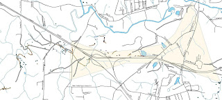
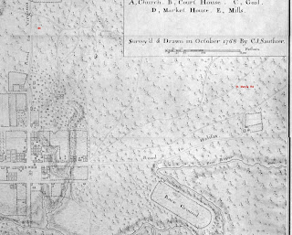
Occaneechi Gap and “Moorefields” Historic Site We blogged about Occaneechi Gap some time back (“An Important Gap in the Piedmont” (December, 2009), now the following note ties Occaneechi Gap to a colonial era historic site just west of gap, “ Moorefields .”  It is more than likely that historic site, now known simply as an antebellum plantation house, is where it is because of the gap; telling the story of one requires the story of the other. Before there was a recognized town at the place we call Hillsborough, there was little reason to use the Eno River fords at or near the great bend of the Eno.  Instead, traffic on an east-west axis in the central piedmont was (and still is) drawn to Occaneechi Gap as an alternative to repeated crossings of the Eno River.  It was more efficient to bypass the Eno by cutting through the gap south of Occaneechi Mountain.  The brown shaded are in the above map defines the gap zone.   This saddle gap, the center of which is just south
Image
A Morgan Creek Ford Along A Lower Course of the Colonial Trading Path to Virginia The Old Ford Finder Bear in mind that in pre-modern times there were, at least, a high road and a low road linking place with place.  The high road stuck to high ground, and it crossed streams high in their course, and found use in times of high water. Morgan Creek Drainage Morgan Creek descends from west-central Orange County southeast to a junction with New Hope Creek, a major Cape Fear head-water.  It sort of cradles or embraces Carrboro and Chapel Hill, North Carolina by bending round their western edge and sliding along their south side before reach New Hope Creek.  It powered some the area's earliest grist mills, and it is one of three barrier streams channeling east-west trade routes through the area.  In low water it may have been a preferred route as the ford at Morgan Creek is on a decent flood plain over which flood waters can spread without rising too much.   The topo map

Ayr Mount, Hillsborough, NC; some hidden features and obscure history

Image
Trading Path Association's October 2011 First Sunday Hike will be at Ayr Mount , a private historic site east of Hillsborough, NC.  "Ayr Mount" is a nineteenth century brick structure preserved and restored with a goodly part of the grounds immediate to the structure protected as well.  We are interested in Ayr Mount, not because of the house or its plantation airs, but rather because before it was Ayr Mount it had another, and from our perspective, far more interesting history altogether.  We'll look at some of the remnants of that earlier history during our hike. The site of Ayr Mount had a lengthy, though obscure, history when Ayr Mount came into being.  This isn't surprising given the quality of the site.  It sits on a well drained knoll, above a river and alongside a good mill stream.  It also sat astride one of the primary road channels East of what became Hillsborough.  It was a potentially valuable holding for whomever owned it. The earliest actual rec