Posts

What were high ways in pre-modern times?

Highways Defined and How They Morph In the 1790s the US Postal Service published standards to be met to qualify to be a postal coach stop.  Among the first was a requirement that your establishment must be situated on 'an all season, all weather road.'  By this, I believe they meant on a high road or high way.  So what did that mean?  What was a high road or a high way?  In short, I believe it meant a road that passed streams high in their course where a passage was seldom if ever obstructed by flood and hewed as close as possible to ridge tops. Highways probably shifted over time as transportation modes and road technology changed. For example, as draft animals grew ever larger in the 19th century so too did payloads. The increased weight tore up dirt roads so counties imposed tire dimension minimums; the heavier the cargo the wider their iron tires needed to be. And the greater the cargo weight the more restricted will be the options for fording stre...

Slaving Native Americans: Recommended reading

Disgrace One way of dealing with disgrace is to pretend it didn't happen, another is to create a false narrative that exonerates the disgraced for what happened in the first place. When considering our Native American populations Americans tend to do both. To our credit, we are conscionable enough to feel disgraced and rightly so as we have throughout our history treated our Native brethren as "other," thus of little or no consequence to our story. Lately, a flood of books has arrived to prevent us from forgetting our past and allow us to revise our narrative to more closely approximate historical facts. A Seldom Noted Fact The bare fact is that much, perhaps most, of the reduction in Native American populations after the European invasion of the Western Hemisphere can be directly and indirectly attributed to slaving the Native population. Our traditional narrative asserts that quite by accident, Europeans introduces diseases against which native peoples ...

Our oldest wagon roads frequently lay atop Native American trails.

Image
'Tis the Season to be out in the woods; visibility good and bugs attenuated. The solstice is over, we are on the way to garden flowers erupting in the middle of nowhere season.  Owing to climate change, that season creeps further up into what we used to call "winter".  We'll start looking for daffodils in January this year.  Last year it was in February\, and the year before that April. We remember when it was an April-May event. Recent finds: Just a week of so ago a friend of the Trading Path Association called to say he thought he'd seen some old, old bridge abutments near his home.  We went for a walk in the woods and, sure enough, he'd found a bridge abutment and it was very old.  [A bit more on dating hypotheses below]  Then we followed the old road course over a little hogback, and down at the bottom of the hogback, on another little creek was another very old bridge. Near by the old roadbed we spotted what appeared to be a "trail tree...
Image
Some notes on the Battle at Weitzel's Mill Weitzel’s Mill, March 6 th , 1781 A few days after The Battle at Clapp’s Mill Cornwallis, determined to bring Greene to battle, launched his own light forces northward to cut Greene’s line of retreat to Virginia.   Greene gave him the chance to do so by maneuvering too far west along Buffalo Creek, his moat.   Greene’s light troops were camped a few miles north of Clapp’s Mill, along Buffalo Road, on Great Alamance Creek, Cornwallis’ moat.   They were all that stood between the overextended Greene and his main line of maneuver.   On March 6 th , very early as was his style, Tarleton, leading a flying column of Cornwallis light forces, marched on the Americans.   Alert pickets picked up the British movement and warned Otho Williams and Henry Lee of the approaching enemy and Williams ordered a retreat to Reedy fork, about ten miles to the north.   The ford at Weitzel’s Mill on Reedy Fork was the only defe...

The East Side of Hillsborough, a well preserved bit of history

Image
The Eastern Edge of Corbin Town: Hillsborough at its Birth idunno Hillsborough was, at its birth, an Anglican enclave in a dissenter district.  Perhaps as part of a plan to reassert Church of England dominance in a decidedly not Church of England colony, Governor Arthur Dobbs and his minions expedited the creation of Orange County (1752).  Though its original seat, its courthouse and seat of government was originally well to the west, two miles from Haw River, that quickly changed.  Within two years the court and seat were relocated to what would in future be called Hillsborough. It was a rude village at the western-most reach of the west fork of the Neuse River.  Why this site was selected remains a mystery as it was a terrible town site, lacking a good water supply.  Colonial government was in the process of shifting from the Cape Fear drainage to the Neuse drainage, and that may have been the reason for locating the new county seat on the Neuse. ...

The Fews on the Eno

Image
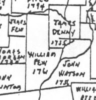
Some Few Facts  Few land grants in ERSP The brothers Few , James (1703-1787) and William (1714-1794) arrived on the banks of the Eno River in Orange County, NC in 1758.  Odds are good that one or both had previously visited the area to scout out land.  It is also likely that, being Quakers themselves, they were acquainted with or even associates of Herman Husband (1724-1795), a Quaker real estate hawker, later, a leader in the Regulator movement.  They arrived in Orange at a pivotal moment in that county’s history involving a contest of wills between the 99% and the 1%. When the Fews arrived, North Carolina’s governor, Arthur Dobbs (1689-1765), keeping a promise made during his job interviews, was in the midst of establishing Anglicanism as the colony’s official religion in a colony in which Anglicans were a miniscule minority.  Perhaps he became governor owing to his family’s long experience doing this sort of thing in Ireland.  His zeal for ...

Settlement north of Albemarle Sound, 1650-1710: the founding of Albemarle

Image
When North Carolina Became a Refuge Albemarle Sound in the northeast corner of modern North Carolina was once, pretty much, the southern reach of  Virginia.  Rivers produced this result, specifically the Roanoke and Chowan Rivers.  Both are difficult to cross and obstruct traffic moving south and west from the Chesapeake.  But east of the Chowan there are two lovely passages for land traffic on the north-south axis, one east of and several west of the Dismal Swamp.  The Dismal Swamp, itself, was essentially impenetrable for most travelers; it was a great place to hide out, but an awful place to pass through.  Into this matrix of channels and barriers fled North Carolina's first permanent settlers, proto-Quakers from Virginia and Maryland.  It can be argued that their flight through "Southside" Virginia, past the Dismal Swamp, and into the buffered lands of the Albemarle District profoundly altered the trajectory of both Carolina and American history....