Posts

Moorefield's Relation to Occaneechi Gap is of more than Orange County importance.
Image
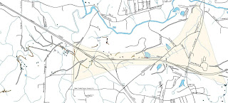
Occaneechi Gap and “Moorefields” Historic Site We blogged about Occaneechi Gap some time back (“An Important Gap in the Piedmont” (December, 2009), now the following note ties Occaneechi Gap to a colonial era historic site just west of gap, “ Moorefields .”  It is more than likely that historic site, now known simply as an antebellum plantation house, is where it is because of the gap; telling the story of one requires the story of the other. Before there was a recognized town at the place we call Hillsborough, there was little reason to use the Eno River fords at or near the great bend of the Eno.  Instead, traffic on an east-west axis in the central piedmont was (and still is) drawn to Occaneechi Gap as an alternative to repeated crossings of the Eno River.  It was more efficient to bypass the Eno by cutting through the gap south of Occaneechi Mountain.  The brown shaded are in the above map defines the gap zone.   This saddle gap, the cente...
Image
A Morgan Creek Ford Along A Lower Course of the Colonial Trading Path to Virginia The Old Ford Finder Bear in mind that in pre-modern times there were, at least, a high road and a low road linking place with place.  The high road stuck to high ground, and it crossed streams high in their course, and found use in times of high water. Morgan Creek Drainage Morgan Creek descends from west-central Orange County southeast to a junction with New Hope Creek, a major Cape Fear head-water.  It sort of cradles or embraces Carrboro and Chapel Hill, North Carolina by bending round their western edge and sliding along their south side before reach New Hope Creek.  It powered some the area's earliest grist mills, and it is one of three barrier streams channeling east-west trade routes through the area.  In low water it may have been a preferred route as the ford at Morgan Creek is on a decent flood plain over which flood waters can spread without r...

Ayr Mount, Hillsborough, NC; some hidden features and obscure history

Image
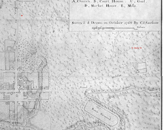
Trading Path Association's October 2011 First Sunday Hike will be at Ayr Mount , a private historic site east of Hillsborough, NC.  "Ayr Mount" is a nineteenth century brick structure preserved and restored with a goodly part of the grounds immediate to the structure protected as well.  We are interested in Ayr Mount, not because of the house or its plantation airs, but rather because before it was Ayr Mount it had another, and from our perspective, far more interesting history altogether.  We'll look at some of the remnants of that earlier history during our hike. The site of Ayr Mount had a lengthy, though obscure, history when Ayr Mount came into being.  This isn't surprising given the quality of the site.  It sits on a well drained knoll, above a river and alongside a good mill stream.  It also sat astride one of the primary road channels East of what became Hillsborough.  It was a potentially valuable holding for whomever owned it. The ea...

Artifacts on the Haw River between Swepsonville and Saxapahaw

Image
Paddle Tour on the Haw River: Swepsonville to Saxapahaw, the middle fords November 27, 2010 Touring rivers is new to the Trading Path Association.  We've walked plenty of river banks, before, looking for remnants of riparian commerce and looking for stream crossings, but the idea of searching a river from the water just hadn't caught on with us, perhaps, because so few Piedmont streams will float a vessel.  We knew, though, a number of stream crossings on the Haw any one of which could be visited in a single afternoon, but to see more than just the one would take far too much time, hence the paddle tour.   In the course of the tour we saw five fords, at least a half dozen dam sites, a couple of power houses that once housed turbines, some sort of occupancy site that may have been a mill prior to government records in the area, and a canal and lock in good enough shape to know what it was even though we couldn't figure out how it work. In other words,...

The Great Central Coast Road in Orange County NC

Image
Travelers from ancient times to the present used Occaneechi Gap when traveling from the Appalachian Mountains to the Atlantic Ocean.  The course they took came to be called the Great Central Coast Path/Trail/Road.  The gap allowed travelers to avoid a one hundred and fifty foot climb and, more importantly, provided a reasonably easy way to bypass the Eno River if one were going down to the ocean and the river was high.  Or if, like John Lawson, you just didn't want to cross any more rivers. Upper Neuse-Cape Fear watershed  One can, without great difficulty, walk all the way from Seven Mile Ck, just west of Moorefields to New Bern without getting your feet wet because just southeast of Moorefields, near the intersection of NC 10 and New Hope Church Rd, the trail intersects the watershed between the Cape Fear and the Neuse River basins.   To the right is a map showing the upper portion of that watershed.  In the upper left the Great Bend of the Eno west...

Earmarks of Settlement

In Anglo-American history, "settlement" is the last stage in conquest, it is when invaders become controlling occupiers rather than: visitors, transients, curiosities, opportunities or necessary evils.  Settlement marks a change in regime, in culture, economy, and society.  On England's first frontier, in the southeast of North America, settlement marked an end to pre-market, subsistence economies, supplanting them with law, centralized order, and markets.  Settlement replaces a life-style rooted in personal freedom with a life-style rooted in personal obligations and liabilities. Participants in subsistence economies live for today and depend on wit, will, and good fortune to survive tomorrow.  Participants in market economies are expected to defer today's joy in the interest of a less frightening tomorrow.  For example, 'starving time,' that time between the consumption of last years's produce and the arrival of this year's harvest was a common ...

A cemetery myth

What We Can Tell From Unmarked Gravestones Recently a neighbor described a "slave cemetery" she'd found. When asked how she had identified it as a slave cemetery, she said the stones were (all but one or two) unmarked. This belief is totally anachronistic. Blank stones, head and foot stones with no inscriptions are not the earmarks solely of slave graves in the South. First, illiteracy was the norm for all three prevalent races in the antebellum South, enslaved and free and, second, some religions disapproved of the use of grave marking. Even amongst sects that took pride in their literacy, inscribed stones could be controversial. Varieties of Quakers and Baptists, alike, have gone through moments of discomfort with grave markings. Many genealogy sites on the internet carry a warning or observation along these lines: "There was a period when Quakers were discouraged from marking their graves. An old Quaker Burying Ground may look as if it is only partially fi...