Posts

TRADING PATH YOUTUBE CONTENT

We have temporarily removed four videos that provide an alternative version Carolina's earliest history. We will rework them into more professional publications and repost them as quickly as possible. As part of the same process we are starting a project to publish on-line the numerous presentations about local and regional history made by the TPA over the past twenty-five years. Be patient, please.

Superannuated and Obsolete: How transportation lore devolved with technological change

According to Webster's Dictionary,the definition for "superannuation" is; "... to make, declare, or prove obsolete or out-of-date." and the definition of "obsolete" (in the same source) is, "... no longer in use or no longer useful." As I am now an octogenarian, I felt a pang today as I decided to throw out my Oxford English Dictionary. It is a doorstop consisting of two large volumes and a supplemental volume in very small, perhaps minuscule print, it came with a magnifying glass neatly stowed in a drawer built into the set box for convenience. It hasn't been used since grad school and merely takes up space and collects dust. But in tossing it, I was reminded of many of my favorite folks from our common history. Perhaps in anticipation of becoming obsolete myself, I have in my history studies given attention to the folks made disposable by technology and economic whim. The characters I've studied I call waymasters as they knew the w...

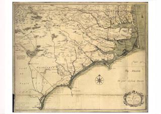
Maybe North Carolina's most telling Map; the Moseley Map, 1733

 In 1733 Emund Moseley was North Carolina's Surveyor General, using his own work probably supplemented by prior work by John Lawson, his predessessor inn that office, produced a map of importance . It is the first published map showing what is now called "Thigpe's Trace", a wagon road arcing across the piedmont, connecting Chesapeake Bay with the Guld of Mexico. It also shows a road matrix in the area north of Albemarle sound that confirms a settlement in that region which dated back to the 1650s. Finally, in an inset map, below the main map, it show's Okracoke Island with an anchorage called "Teaches Hole" immediately off-shore, near a large well, a well suitable for replenishing ships quickly. As Captain Teach was hung for piracy ca 1715, the well is likely to have predated his demise. Taken altogether, it makes North Carolina's history  far more interesting than convention teaches it For example, our history books date the settlement of the piedmo...

The Barnwell-Hammerton Map

Image
 The Barnwell-Hammerton Map, c 1715, showing three routes taken to recruit native levies for the Tuscarora War by two Moore's from Turkey Creek and Cape Fear, and "Tuscarora Jack" Barnwell.

Ancient Food Preservation Methos

 Bog butter, butter than nothing, soggy mammoth, challenging but tasty with seasoning.

Squatters in Orange County in the 17th and 18th Centuries

Squatters in Orange County in the 17th and 18th Centuries In the 1740s there were two very hot properties in what would, in the 1750s, become Orange County, North Carolina.  Those were the Haw Fields and the Forks of the Eno.   They were attractive for different reasons; the Haw Fields for fecundity, and the Forks for transportation accessibility........probably.  We'll deal with the Haw old fields another time.  This note is about the forks of the Eno. We are only beginning to get a vague image of European settlement in what would become Orange County, NC.  Until recently "settlement" was presumed to have begun with deed recording in Orange's parent counties; normally thought of as Johnston, Bladen, and Granville Counties.  We know, though, that folks were making "tomahawk" claims on land in Carolina long before law came to town.  We just don't know how many folks were in the area or where they were.  They were, though, in the area, pr...

Videos of slide shows on early Carolina History, pre-contact through 1754

Four Presentations on Early Carolina History The Trading Path Association is grateful for the Orange County Hstorical Museum producing these presentations. And for their ongoing support of our work. First Contact :1624-1700 Tells how indigenous societies traded extensively, had sophisticated diplomacy, contracting methods, and struck up trade with practically every maritime vessel that entered the Sounds. They turned the Sounds into a major replenishment haven for privateers and pirates. First Permanent Settlement : 1650s-1705 Identifies Carolina's first settlers and first permanent settlement, religious refugees sheltering behind the Dismal Swamp from abuses byRoyalist, VA and Catholic MD. Moving Into the Back Country : 1705-1754 Describes how the first settlers, displaced by Anglicans once again escape into the backcountry, the piedmont zone, and sheltered indigenous folk from slave raiders. Touching on the varieties of Quakers in NC and the importance of their differences. The L...
  Wonderful dendro geekery proves the European invasion of NA started in precisely 1021:

TPA ACCOMPLISHMENTS

TPA ACCOMPLISHMENTS 8/04/2020 Trm [ In causa mortis it seems appropriate to assemble a list of the Trading Path Association's accomplishments over the past twenty years. Most of those accomplishments are indirect as planned. Starting in 2000 we raised money solely to pay for transportation costs and we set off on a campaign to goad others to do the smart thing and preserve historical artifacts.]  What We Did We operated at the county level in Virginia, North Carolina, South Carolina and Georgia. Time and resource availability eventually limited our operation to North Carolina. Our method was to contact and meet with county and city managers to pitch them on heritage tourism as a  low cost and high return economic development. Tourists come, spend and leave so there is no requirement for infrastructure and payroll increases; roads, police, and more firemen needed, just signage. Our successes from north to south include: Petersburg, VA: Long term plan to locate and excavate Abra...

"Thigpen's Trace"

Image
THIGPEN TRACE “Thigpen Trace, the oldest military road in Georgia, was cut by James Thigpen to transport military supplies of Col. James Moore, former Carolina governor. It followed a well beaten trail of the Indians from the mountains to the sea in use before the era of the white man. Coming from South Carolina above the Broad River, along the Chattahoochee water divide to the Gulf of Mexico, it avoided all swamps and great rivers. The English claimed the territory as Carolina while the Spanish claimed it as Florida. Col. Moore led the English in an attack down Thigpen Trail  and “made Carolina as safe as the conquest of the Spanish and Appalachee (Indians) can make it.” GHM 159-3 GEORGIA HISTORICAL COMMISSION 1956 Perhaps the most important road in North Carolina history,  Thigpen's Trace is a road most have never heard about. It has a highway marker in Georgia but none in South Carolina, Virginia, and North Carolina. It dates back to 1704 and profo...